


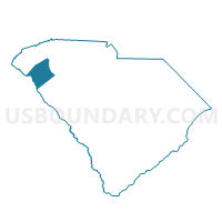
Honea Path Voting District, Anderson County, South Carolina
About
Outline

Summary
| Unique Area Identifier | 664991 |
| Name | Honea Path Voting District |
| County | Anderson County |
| State | South Carolina |
| Area (square miles) | 1.76 |
| Land Area (square miles) | 1.76 |
| Water Area (square miles) | 0.00 |
| % of Land Area | 100.00 |
| % of Water Area | 0.00 |
| Latitude of the Internal Point | 34.44270030 |
| Longtitude of the Internal Point | -82.40034700 |
Maps


Graphs
Select a template below for downloading or customizing gragh for Honea Path Voting District, Anderson County, South Carolina


Neighbors
Neighoring Voting District (by Name) Neighboring Voting District on the Map
- Barker's Creek Voting District, Anderson County, SC
- Broadmouth Voting District, Abbeville County, SC
- Chiquola Mill Voting District, Anderson County, SC
- High Point Voting District, Anderson County, SC
- Keowee Voting District, Abbeville County, SC